The National Weather Service (NWS) warns of a significant late-season winter storm set to impact parts of Wyoming and Colorado. This storm will bring up to 20 inches of snow and wind gusts reaching 60 mph. It poses severe travel challenges, potential power outages, and risks near-zero visibility.
Local Impacts: Power Outages and Daily Disruptions
The storm’s effects extend beyond travel issues, causing local disruptions, such as:
- Power outages due to snow accumulation on power lines and tree branches.
- Significant impacts on Monday morning and evening commutes.
- Difficulty accessing rural and elevated areas.
- Possible school and service disruptions, particularly in elevated regions.
- Hazardous outdoor work conditions.
- Potential tree damage, especially where trees have spring leaves.
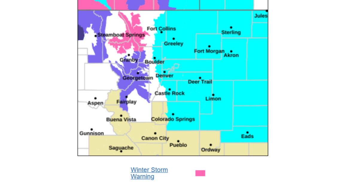
Winter Storm Overview: Targeted Areas
NWS winter storm warnings affect large areas of Wyoming and Northern Colorado, especially higher elevations and mountain corridors. The most affected areas include:
Colorado
- Areas above 9,000 feet.
- Rocky Mountain National Park.
- Medicine Bow Mountains and Rabbit Ears Range.
Wyoming
- Snowy Range and north Laramie Ranges.
- Wind River Mountains.
- Sierra Madre Range.
- Casper Mountain.
- Interstate 80 corridor near Arlington and Elk Mountain.
Forecast Conditions
Heavy, wet snow will likely cling to trees and structures. Winds of 30 to 60 mph will cause blowing and drifting snow, reducing visibility. Conditions are expected to worsen rapidly from Sunday night into Monday.
Snowfall Expectations
Snow accumulation will vary by elevation and area:
Colorado
- Rocky Mountain National Park and Medicine Bow Range: 8 to 18 inches, heaviest on east-facing slopes.
Wyoming
- Snowy Range and north Laramie Range: 10 to 20 inches, with winds up to 40 mph.
- Wind River Mountains (East): 9 to 18 inches locally, with gusts to 60 mph.
- Casper Mountain: 10 to 18 inches, winds up to 40 mph resulting in reduced visibility.
- Sierra Madre Range: Up to 15 inches, with winds up to 50 mph causing blowing snow.
Travel Warnings
Travel will be dangerously impacted, especially in high elevations and major routes.
Key concerns include:
- Snow-covered, icy roads, especially on bridges and overpasses.
- Blowing snow and whiteout conditions.
- Sudden visibility drops to less than a quarter-mile.
- Increased risk of stranded vehicles.
Affected routes include:
- Interstate 80 in Wyoming near Arlington and Elk Mountain, and the Laramie Range.
- Highway 20 to 26 between Hiland and Casper in Wyoming.
- Mountain passes, like Cameron Pass and Willow Creek Pass in Colorado, and South Pass in Wyoming.
The NWS advises drivers to delay travel if possible or equip themselves with emergency supplies, such as food, shovels, water, and flashlights. Allow extra time and maintain distance between vehicles as conditions can change swiftly.
Key Takeaway
This storm is a significant late-season event, with heavy snow, strong winds, and extensive travel hazards in Wyoming and Northern Colorado. It urges residents to prepare and avoid unnecessary travel, as conditions will deteriorate rapidly through Monday.
 New Jersey Struggles with Protests Near Immigration Detention Center
  Newark Scales Back Police Presence at Detention Center Protests
  Investigation into Bus Company’s Network and Safety Violations
  Inflation’s Rise Challenges Economists’ Claims
  Support Pours in for Airport Worker After Viral Video
  Father Shares Water Safety Lesson After Daughter’s Close Call